HOQUARTON INTERPRETIVE TRAIL AKA HOQUARTON LANDING
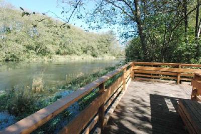
The Hoquarton Slough once served as a water route to the City of Tillamook, Oregon, for supply, passenger, and fishing boats entering Tillamook Bay from the Pacific Ocean. Before Pioneer settlement, the Tillamook Indian Tribe hunted and fished in and around the slough’s rich natural environment. The Hoquarton Interpretive Trail was built in a cooperative effort between the City, volunteers and a number of granting agencies.
The park is Located along the banks of the slough just one block north of the heart of the downtown area next to the new four-lane bridge at Front Street and Highway 101.
In the early 2000’s the trail and park areas were cleared of invasive plants and restored to its natural vegetation. It began with a multi-year process that combined ideas and concepts developed by dozens of local citizens, elected officials and representatives of various governmental agencies and organizations, primarily the City of Tillamook and the Tillamook Estuaries Partnership, with assistance from the National Park Service’s Rivers, Trails and Conservation Assistance Program for the Pacific West Region based in Seattle, Wash. City crews graded the center section and placed interpretive signs provided with a grant from Tillamook Estuaries Partnership. The east end and center section are planted with memorial trees provided by the Tillamook chapter of AAUW.
In conjunction with an Oregon Department of Transportation Intersection Project and the construction of a new four-lane bridge over the Hoquarton Slough completed in 2018, the park was renovated and a new parking lot was constructed. Along with new park renovations a crosstown connection route from the Hoquarton Interpretive Park to the Goodspeed Park on 3rd Street was constructed. This connection route is mostly paved with only a small gravel section.

